
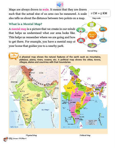
Page 174 - Arrow Publications Pvt. Ltd.
P. 174
When designing  a map, we  use  specific  pictures,  signs, and colours  to

          represent various features. They are called symbols. Symbols are in picture

          form, representing real-world things around us. For example, railway lines,

          buildings, bridges, rivers, etc. These symbols help us understand maps better.


                 Railway            Bridge          Tower          Building      Lighthouse           River


          Most maps have a map legend. A key or

          legend in a map tells us the meaning of

          the  symbols  used  on a map. Different
          symbols  are drawn in different  colours.

          Water bodies such as lakes, rivers, seas,

          oceans are coloured  in blue, land is                                                 LEGEND

          coloured in yellow, mountains and deserts                                            water bodies

          are coloured in brown. Parks and forests                                             land
                                                                                               mountains & deserts
          are coloured in  green. Major highways
                                                                                               forests
          are coloured in red.                                                                 highways


                                                                                  Map Key or Legend


             Think &
             Answer     Are there any landmarks you see on your way to school? Do you notice these
                        landmarks when you return home? Name a landmark near your home.

          Globe


          We cannot see the entire Earth at one time as it is very big in
          size. So, we use smaller model of the Earth. This model of the

          Earth is called globe. Continents and Oceans are shown how

          exactly they are on the Earth. As the globe is round in shape

          we must keep turning the globe to see all the continents and

          oceans. A globe, like a map, is made to a scale.
                                                                                                      Globe
                                                                                                              173
                                                                                               Arrow - EVS Plus - 4 | 173